
![]()
|
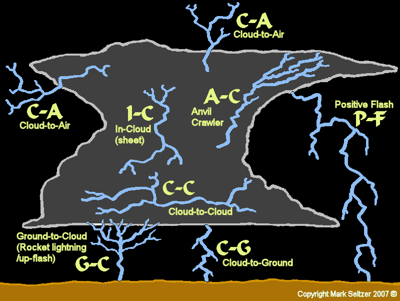
Lightning Types
The above schematic
demonstrates the seven most observed types of tropospheric lightning from a cumulonimbus cloud. Some
thunderstorms I've observed produce nothing but I-C (sheet) lightning,
whilst others are prolific C-G (cloud to ground) generators. Some produce all
types throughout the lifecycle of the cloud. My theory, after decades of
observations, is the abundant type of lightning
is likely dependant on 3 main factors: vertical shear (winds at different
heights dictating the cloud/electric field structure), vertical velocity
(updraught downdraught speed and angle) and overall cloud structure (how
many cells, where is the freezing level in relation to anvil top, how high
is the tropopause, etc). |
||
|
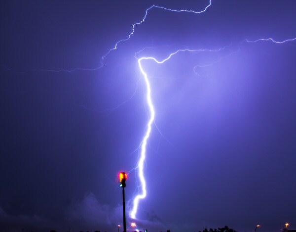
Cloud to Ground (C-G) aka Forked Lightning |
||
|
|
These well-known strikes are
the most dangerous (after Positive Flash) to infrastructure, humans and
animals during a thunderstorm, and prized in lightning photography. A lightning channel originating from the (traditionally) negative
region in low-mid areas of a cumulonimbus cloud extends to a positively charged ground. These can
vary in amplitude depending on the altitude of the negative region/freezing levels and other
environmental conditions. The accepted theory of generation is via a faint
"stepped leader" from the negative region, "feeling" it's way to a
positively charged ground, launching a faint positive streamer upwards,
connecting, then the current flows and you get the flash and the bang. In
photos, you can often see downward-pointing branches coming off the main
channel. These are a result of those "feeling" stepped leaders and are
usually only visible milliseconds before the circuit is closed. |
|
|
|
||
|
Intra-Cloud (I-C) aka Sheet Lightning (resembling a sheet of light in the sky) |
||
|
|
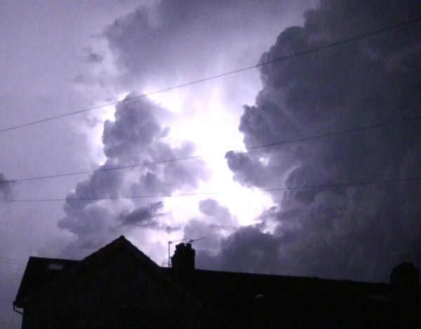
Lightning in tall
cumulonimbus clouds mostly occurs within the cumulonimbus cloud itself, between the
dipole region of an individual cell
or between different cells. More often than not they are obscured to the
observer, so the cloud lights up like a bulb. Typically severe "warm
airmass" thunderstorms
produce a lot of I-C in the upper regions of the cumulonimbus cloud, with
apparently "quiet" distant rumbling thunder, and occasionally lower in the cloud
in weaker thunderstorms which give a better rumble. If the cloud is
well-sheared (leaning) then you're more likely to see these discharges as
C-C. |
|
|
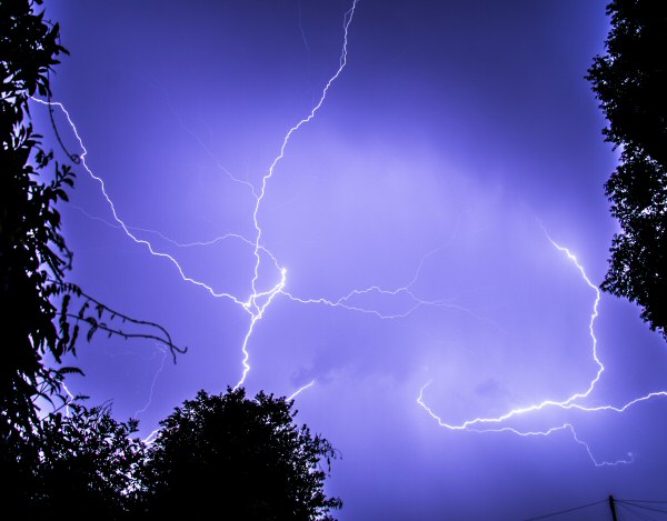
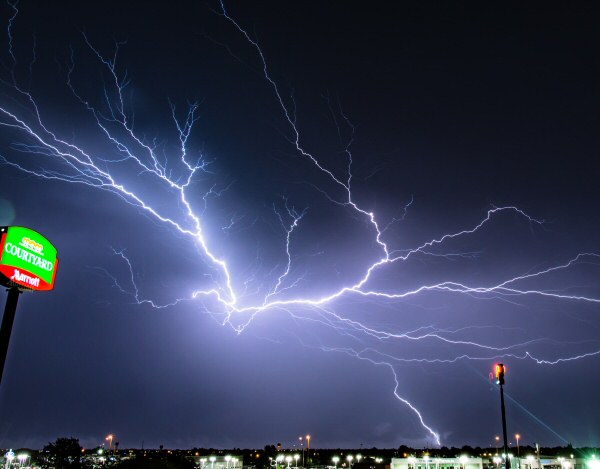
Cloud to Cloud (C-C) aka Spider / Streaked Lightning |
||
|
|
These non-ground connecting lightning streaks often occur between adjacent areas of charge in the horizontal
along a precipitating cloud base (rather than the vertical like I-C). These
are common in sheared thunderstorms (leaning vertically) where what may have been an
I-C is now visible because the dipole is stretched laterally along an
exposed downdraught underbelly, and also
common in mid-level multicells where the charge distribution is chaotic
and the cold regions of the storm are more visible due to the higher
cloud base.
They usually have
fairly low luminosity and produce weak crackly thunder indicating low-amp
nature. On the other hand some discharges may be large and chained together
with other lightning channels throughout the whole storm cloud (much
flickering and "crawling"), resulting in a more powerful, brighter
discharge. Likely location: Widespread, usually between the base of updraught and downdraught regions, or between two or more individual cells. Requirements: Negative and positive regions side-by-side, preferably just outside or into to charged precipitation curtains. Multicells and mid-level AcCast thunderstorms flaunt C-C. Look Left: A large mid-level multicell of chaotic structure reflects this chaos in a seemingly aimless spray of lightning channels connecting different updraught points and precipitation curtains. |
|
|
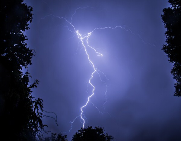
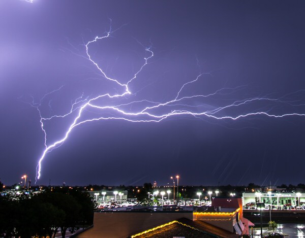
Anvil-Crawler (A-C) aka Spider / Streaked Lightning |
||
|
|
This powerful,
photogenic but silent form of Cloud to Cloud thrives in large linear sheared
thunderstorms (forward or rearward sloping)
where large areas of positive anvil spreads quickly away from the negative
towers. These mega-C-Cs are often seen visibly crawling along the underside of
these large anvils, some 7000-35,000ft altitude, spreading the discharge across
multiple channels for tens of miles, crawling and flickering as the parent
channel encounters new areas of charge along the way.
Due to the altitude and spread of charge, A-Cs are often relatively quiet.
They can also occur in old storms, where a stray negative stepped leader
finds fields of unused positive charge and discharges the whole lot at once,
only for the storm to go completely silent thereafter. Likely location: Underneath the newest part of a widely advecting Anvil, connecting to the parent cumulonimbus tower. Requirements: Strong, well-sheared or linear rearward/forward sloping cumulonimbus structures, where fresh positively charged anvil-spread is dense, vast and quick, and efficiently sheared away from the negative regions in the main cumulonimbus towers (i.e. the Anvil has plenty of unused positive charge). Look Left: By far my best A-C capture of many. These are sometimes accompanied by C-G (often the C-G is the initial trigger), or extend from the tops of Ground to Cloud lightning (see G-C). |
|
|
Positive-Flash (P-F) aka: Anvil Lightning / Bolt from the Blue / Positive C-G |
||
|
|
This type of lightning
occurs when a C-G originates from a positive region,
which is usually high-altitude in the upper level parts of a cumulonimbus
tower or fresh anvil formation.
The P-F extends all the way to the ground from such heights of 20,000-35,000ft (up to 8-10 times the length of a normal C-G).
The electric field (potential difference) involved here is staggering, and
therefore these are often the most powerful type of lightning you can get,
resulting in explosive cannon-fire thunders. They can either
occur outside the cumulonimbus tower ("bolt from the blue") or under a
strongly charged anvil. Some can take an internal path and appear to the observer as high-amp
base-C-Gs. Three key give-aways are the loudness and long duration of the thunder,
and also sometimes a smooth or straight-line channel (less jagged and
chaotic).
Likely location:
Out of
newly-produced anvil cloud or top of a cumulonimbus tower. Often seen in
tropical CBs, temperate winter CBs, and NE of the core of a mature supercell. |
|
|
Ground-Cloud (G-C) aka: Up-flash / Rocket Lightning |
||
|
|
These reverse-C-Gs have been seen to sprout from the tops of tall
pointy objects.
They happen traditionally when a negatively charged region on the ground
connects to a large area of positive charge in the cloud above, usually the
anvil. The top of the channel may convert into an A-C (Anvil Crawler) as
shown left. The illusive characteristic of these discharges
is that it appears as a progressive upward-moving Anvil-Crawler with reverse
upward-pointing branches, which is
where the slang names
“up-flash” or “rocket lightning” come from. The leader channel often has
long duration due to the progressive nature of the discharge. They are
thought to be more common in the age of humans given most of these
discharges are encouraged by tall man-made objects, although they have been
photographed coming off pointy mountain tops such as volcanoes.
Likely
location:
underneath strong positively charged clouds (often the underside of a
large anvil) occurring from tall buildings, mountains, wind turbines or
transmitter towers. Look Left: This G-C was probably the 4th or 5th one to be launched from this distant transmitter tower. Note the direction of the branches indicating the direction of lightning travel, converting into an anvil-crawler downstream |
|
|
Cloud-Air (C-A) |
||
|
|
As the name suggests,
these are
lightning channels travelling into clear air. Their classification is open
to question, as subsidiary branches off the leader channel of CGs, for
example, are commonly seen disappearing into clear air or into precipitation
curtains. My interpretation is a true C-A should be seen to be terminating into clear air for some considerable distance outside of the
cloud structure. These seem to happen more often near the tropopause (anvil
height) whilst perhaps being accompanied with a P-F. For this type of
lightning to be seen, the thunderstorm needs to be observed from a
distance. The charge separation into thin air is not well understood, but
could be caused by regions of charged air left behind from evaporated
areas of previously charged cloud.
Or perhaps there are some interactions with the stratosphere or ionosphere that
are not fully understood. These are not quite the same as capturing stray
unsuccessful stepped leaders on camera (which usually go everywhere), as they appear
bright enough to suggest
current flow is more definite, determined and final. Likely location: Tops of freshly developed cumulonimbus clouds near the tropopause, or branching off a P-F into blue/clear skies. Requirements: Strong fresh, usually positively charged anvil-spread, external P-F risk, and a good view. Look Left: One of my only captures of C-A. Several channels of lightning coming from the top of an cold-air low-topped cumulonimbus (PS0001). The video frame that followed this one showed one of these channels developing into a P-F. |
|
|
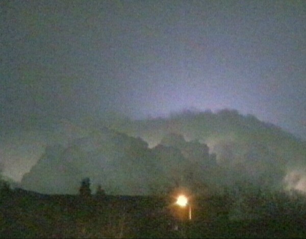
Heat Lightning (H-L) |
||
|
|
Heat lightning is the name given to distant flashes that
can be seen on the horizon from distant thunderstorms. It gets its name from old folklore,
when during hot summer
months in temperate climates a thunderstorm is seen
on the horizon lightning up the atmosphere and clouds immediately
around it, but no thunder is heard. Likely location: along thundery frontal systems or convergence zones lasting into the night at a distance.
Requirements:
Well-forced MCS or
linear thunderstorm in the distance, with continuous flickering, and a fair
amount of clear sky around it. |
|
|
Crown Flash / Leaping Sundog (Confirmed Optical/Electrical Phenomenon) |
||
|
|
Very exotic and rare,
but becoming increasingly documented thanks to the abundance of camera phones. This is
actually a daytime optical effect, caused by a
thunderstorm's electric field. Under perfect situational conditions, it is
hypothesised that the orientation of long thin ice crystals outside the
cloud align with the intense electric field of the cumulonimbus, like iron
filings. These orientated ice crystals then reflect the
sunlight at a particular angle to the observer. It was first reported in
1885 by an explanation in the Monthly Weather Review journal. It can look
like aurora or torch-light coming out of the top of a thunderstorm, and
mechanically dances as the electric field changes within the storm. Looping
can sometimes be seen during field reconnection events, akin to magnetic
fields on the Sun. Only possible to see in daylight due to the requirement
to reflect sunlight (perhaps moonlight?). Truly fascinating and one for the bucket list!
http://amasci.com/amateur/sundog.html
Likely location: Above a freshly formed Cumulonimbus crown (before spreading to Anvil) if thin ice crystals are present above.
Requirements:
Thin layer of ice crystals above a strong,
freshly developed cumulonimbus, like a pileus or high humidity layer at the
tropopause (translucent Cirrus), and sunshine nearby (perhaps ~22 degrees
aside which is what Sundogs rely on). |
|
|
Ball Lightning (B-L) (Unconfirmed Electrical Phenomenon) |
||
|
Most people have heard of the legendary myth of Ball Lightning, but no one has ever achieved any valid evidence of its existence, even with our smart phone/CCTV abundance in recent years. It is thought to be a plasma-ball phenomena occurring close to the ground during thunderstorms, and usually in urban areas. Some people have claimed to film or photograph orbs floating around cumulonimbus towers aloft, but are nearly always identified as aircraft or helicopters avoiding the thunderstorm by flying around it. Likely location: urban areas close to the surface. |
||
|
ELECTRIC SKY LIGHTNING AMPLITUDE CLASSIFICATION |
||
© Mark Seltzer
www.electricsky.co.uk